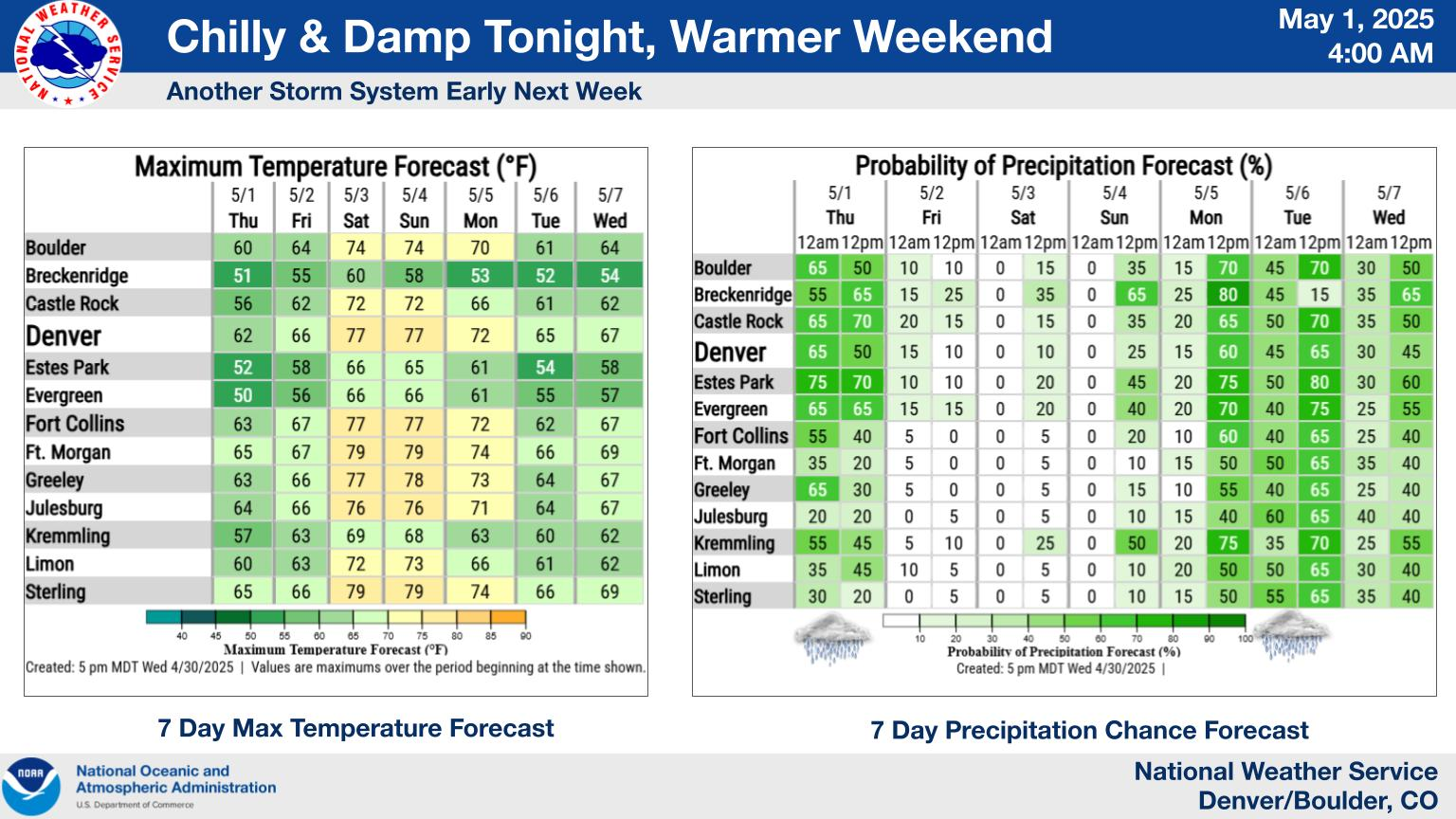
The strongest wave of a three-day spring storm will hit Colorado on Tuesday, bringing up to 20 inches of snow to the mountains and up to 4 inches of rain in lower elevations, according to the National Weather Service.
Forecasters said the most rain is expected to fall in the foothills west of Denver and southeastern Colorado. According to the weather service, one inch of rain is equally wet as about 13 inches of snow.
As of Tuesday morning, rain forecasts included:
- Between 2 and 3 inches of rain in the foothills west of Boulder
- Between 1 and 1 1/2 inches of rain in the Denver area
- Between 2 and 3 inches of rain in Colorado Springs and Woodland Park
- Up to 4 inches of rain west of Colorado Springs
- Between 1 and 1 1/2inches of rain near Denver International Airport and parts of the Eastern Plains, including Limon and Bennett
- Up to 1 inch of rain in northern Colorado, including Estes Park and Red Feather Lakes
- Between 3 and 4 inches of rain from Canon City to Rye in southern Colorado
- Between 2 and 3 inches of rain in Pueblo, Trinidad, Walsenburg, La Junta and Springfield
- Between one-fourth and one-half inch of rain east of the Interstate 25 corridor in southern Colorado
- Less than one-fourth inch in the northeastern plains
Travel may be difficult Tuesday afternoon and evening in Colorado’s mountains, including along Interstate 70 east of the Eisenhower Tunnel, U.S. 40 over Berthoud Pass, Kenosha Pass and along the higher elevations of the Peak to Peak Highway, according to a NWS Hazardous Weather Outlook.
Forecasters said 10 to 20 inches of snow are forecast for the Front Range mountains above 8,000 feet. The heaviest snow will fall above 9,000 feet, according to the outlook.
Jackson, Larimer, Grand, Boulder, Gilpin, Clear Creek, Summit and Park counties above 9,000 feet are under a Winter Storm Warning from Tuesday until 6 a.m. Wednesday.
Wednesday will have lingering showers before tapering off late in the evening, forecasters said in the outlook. After that, warm temperatures are expected to return through the weekend.
Get more Colorado news by signing up for our daily Your Morning Dozen email newsletter.