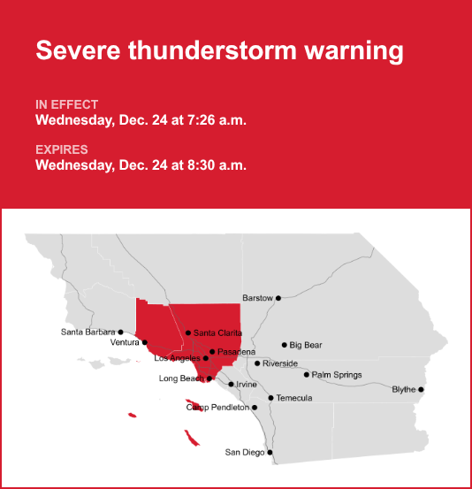
Los Angeles and Ventura counties are included in an updated severe thunderstorm warning released by the National Weather Service on Wednesday at 7:26 a.m. The warning is in effect until 8:30 a.m.
Residents should be prepared for wind gusts of up to 60 mph.
“At 7:26 a.m., severe thunderstorms were located along a line extending from near Fillmore to near Thousand Oaks to Malibu, moving east at 25 mph,” according to the NWS Los Angeles/Oxnard CA. “Expect damage to roofs, siding, and trees.”
Locations impacted by the warning include Thousand Oaks, Simi Valley, North Hollywood, Encino, Woodland Hills, Malibu, Agoura Hills, Van Nuys, Chatsworth, Santa Clarita, Beverly Hills, Northridge, Santa Monica, Hollywood, Moorpark, Sylmar, Studio City, Interstate 405 through the Sepulveda Pass, Pacific Palisades and Porter Ranch.
The NWS said, “Remain alert for a possible tornado! Tornadoes can develop quickly from severe thunderstorms. If you spot a tornado go at once into the basement or small central room in a sturdy structure. For your protection move to an interior room on the lowest floor of a building. Torrential rainfall is occurring with these storms, and may lead to flash flooding. Do not drive your vehicle through flooded roadways.”

Road closures
Updates on road closures can be found on CalTrans’ website or mobile app or by calling 800-427-7623.
Emergency alerts in Southern California
For “considerable or catastrophic” hazards, emergency alerts will be sent to all enabled mobile phones in the area. To monitor lesser risk, residents are advised to sign up for county alert systems and to monitor agencies’ social media. How to sign up for alerts in your area:
Where to get sandbags
If you’re in an area at risk of flooding, sandbags can be one line of defense. County fire departments typically offer a limited supply of free sandbags for residents of their nearby communities. You should bring your own shovel to fill your bags, and be prepared to show proof of residency.
Sand and sandbags can also be purchased at many home improvement and hardware stores.
Here are links of locations that might have sandbags in your area:
Los Angeles County https://dpw. Lacounty. Gov/dsg/sandbags/
Orange County https://ocfa. Org/AboutUs/Departments/OperationsDirectory/Sandbags. Aspx
San Bernardino County https://sbcfire. Org/sandbags/
Riverside County https://rvcfire. Org/resources/fire-stations
How to fill a sandbag
Not sure how to fill your sandbags? Watch the how-to video, provided by the City of Seal Beach.
Preparing for impending lightning strikes: Expert safety recommendations
Each year, lightning strikes the United States approximately 25 million times, mostly during the summer. It claims the lives of about 20 people annually, according to the NWS. The threat of lightning becomes more pronounced as thunderstorms draw nearer, peaking when the storm is directly overhead and gradually waning as it moves away.
To ensure your safety during a thunderstorm, consider the following recommendations:
Lightning safety plan:
- When venturing outdoors, it’s crucial to have a lightning safety plan in place.
- Monitor the sky for threatening signs and listen for the sound of thunder. If thunder is audible, it’s an indication that lightning is nearby.
- Seek shelter promptly in a safe location, preferably indoors.
Indoors safety measures:
- Once you’ve found shelter indoors, abstain from using corded phones, electrical appliances, or plumbing fixtures, and refrain from approaching windows and doors.
- Lightning can follow conductive pathways, and these precautions reduce the risk of electrical surges.
Wait for the all-clear:
- After the last lightning strike or thunderclap, wait at least 30 minutes before resuming outdoor activities.
- Lightning can strike even when a storm has seemingly passed, so exercise caution.
When indoor shelter isn’t available:
If you find yourself outdoors with no access to indoor shelter during a thunderstorm, take these steps to maximize your safety:
- Avoid open fields, hilltops, or ridge crests, as they expose you to greater lightning risk.
- Steer clear of tall, isolated trees and other prominent objects. In forested areas, stay close to lower stands of trees.
- If you’re with a group, ensure individuals are spread out to prevent lightning current from transferring between people.
- Camping in an open setting during a thunderstorm is strongly discouraged. If you have no alternative, set up camp in a valley, ravine, or other low-lying areas. It’s crucial to note that a tent provides no protection against lightning.
- Do not approach water bodies, wet objects, or metal items. Although water and metal do not attract lightning, they conduct electricity effectively and can pose significant risks.
In summary, when facing the threat of lightning, preparedness and vigilance are your best allies. By following these guidelines, you can significantly reduce the likelihood of lightning-related incidents and prioritize your safety.
Rainy roadways ahead: Essential safety tips for heavy rain
Heavy rainfall may lead to flooding if prolonged or if there is excessive runoff. Excessive runoff can be a result of saturated ground and/or rainfall intensity. Follow these recommendations from the NWS to stay safe in heavy rain:
Beware of rapid water flow:
During heavy rain, avoid parking or walking near culverts or drainage ditches, where swift-moving water can pose a serious risk.
Maintain safe driving distances:
Adhere to the two-second rule for maintaining a safe following distance behind the vehicle in front of you. In heavy rain, allow an additional two seconds of distance to compensate for reduced traction and braking effectiveness.
Slow down and stay cautious:
On wet roads, reducing your speed is crucial. Ease off the accelerator gradually and avoid abrupt braking to prevent skidding.
Choose your lane wisely:
Stick to the middle lanes to minimize the risk of hydroplaning. Outer lanes are more prone to accumulating water.
Prioritize visibility
Enhance your visibility in heavy rain by activating your headlights. Be particularly vigilant for vehicles in blind spots, as rain-smeared windows can obscure them.
Watch out for slippery roads:
The initial half-hour of rain is when roads are slickest due to a mixture of rain, grime, and oil. Exercise heightened caution during this period.
Keep a safe distance from large vehicles:
Large trucks and buses can reduce your visibility with tire spray. Avoid tailgating and pass with caution.
Mind your windshield wipers:
Overloaded wiper blades can hinder visibility. If rain severely limits your sight, pull over and wait for conditions to improve. Seek refuge at rest areas or protected spots.
If the roadside is your only option, pull off as far as possible, preferably past the end of a guard rail, and wait until the storm passes. Keep your headlights on and turn on emergency flashers to alert other drivers of your position.
By following these safety measures, you can significantly reduce risks and ensure your well-being when heavy rain pours down. Stay informed about weather conditions and heed advice from local authorities to make your journey safe and sound.
For more local weather alerts, visit our Weather Advisory page