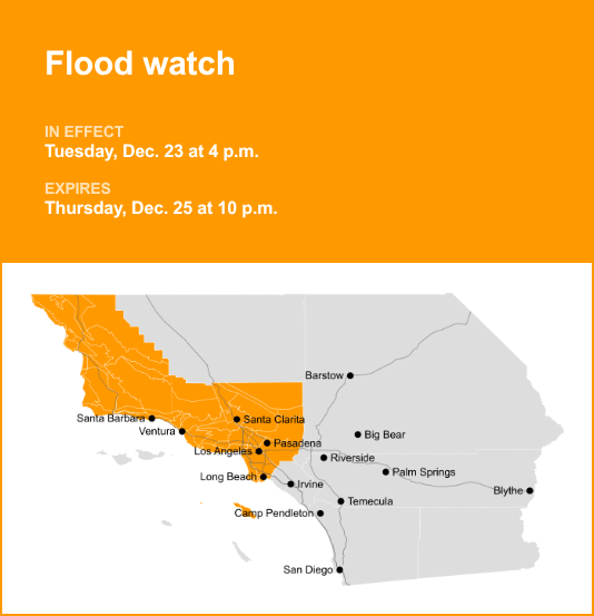
Los Angeles County is included in a flood watch released by the National Weather Service on Tuesday at 12:22 p.m. The watch is valid from 4 p.m. until Thursday Dec. 25, at 10 p.m.
The NWS Los Angeles/Oxnard CA adds to expect, “Significant and widespread flooding caused by excessive rainfall will be likely, with potential debris flow impacts across recent burn scars.”
“This prolonged strong Atmospheric River storm system will bring periods of heavy rain from late Tuesday into Thursday evening. Potential flooding impacts include the threat of significant and widespread urban roadway flooding, a high risk of major rock/mudslides, and rapid rises in creeks, streams, and rivers which will likely lead to swift water rescues. The recent burn scars will be at risk for debris flows, possibly damaging. These flooding impacts will likely lead to significant travel delays and road closures during this busy holiday travel period,” according to the NWS. “You should monitor later forecasts and be alert for possible Flood Warnings. Those living in areas prone to flooding should be prepared to take action should flooding develop.”
The full list of affected locations includes:
- Catalina/Santa Barbara Islands
- Santa Clarita Valley
- Los Angeles County Beaches
- Palos Verdes Peninsula
- Los Angeles County Inland Coast including Downtown Los Angeles
- Western Santa Monica Mountains Recreational area
- Eastern Santa Monica Mountains Recreational area
- Calabasas/Agoura Hills
- San Fernando Valley
- Santa Susana Mountains
- 5 Freeway corridor near Santa Clarita
- Western San Gabriel Mountains/Highway 14 Corridor
- Eastern San Gabriel Mountains
- Western Antelope Valley Foothills
- Eastern Antelope Valley Foothills
- Antelope Valley
- San Gabriel Valley
- Cuyama Valley
- San Luis Obispo County Beaches
- San Luis Obispo County Inland Central Coast
- Santa Lucia Mountains
- Southern Salinas Valley
- San Luis Obispo County Interior Valleys
- San Luis Obispo County Mountains
- Santa Barbara County Central Coast Beaches
- Santa Barbara County Inland Central Coast
- Santa Ynez Valley
- Santa Barbara County Southwestern Coast
- Santa Barbara County Southeastern Coast
- Santa Ynez Mountains Western Range
- Santa Ynez Mountains Eastern Range
- Santa Barbara County Interior Mountains
- Ventura County Beaches
- Ventura County Inland Coast
- Lake Casitas
- Ojai Valley
- Central Ventura County Valleys
- Southeastern Ventura County Valleys
- Southern Ventura County Mountains
- Northern Ventura County Mountains
Deciphering advisories, watches, and warnings: Understanding weather alerts
- Flash flood warning: Take action!
A flash flood warning is issued when a flash flood is either imminent or already occurring. In flood-prone areas, it’s crucial to move immediately to higher ground. A flash flood is a sudden and violent inundation that can develop within minutes to hours, and it can even happen in areas not currently experiencing rainfall.
- Flood warning: Take action!
A flood warning is issued when flooding is imminent or occurring.
- Flood advisory: Be aware:
A flood advisory is issued when flooding is not expected to be bad enough to issue a warning. However, it may cause significant inconvenience, and if caution is not exercised, it could lead to situations that may threaten life and/or property.
- Flood watch: Be prepared:
A flood watch is issued when conditions are favorable for flooding. It does not mean flooding will occur, but it is possible.
Weathering the storm: Flood safety guidelines from the NWS
In flood-prone regions or while camping in low-lying areas, understanding and following the NWS flood safety guidelines can be a lifesaver:
Seek higher ground:
If you’re in a flood-prone area, or if you’re camping in a low-lying spot, move to higher ground as a first step.
Follow evacuation orders:
When local authorities issue an evacuation order, promptly comply. Before leaving, secure your home by locking it.
Disconnect utilities and appliances:
If time allows, disconnect your utilities and appliances. This reduces the risk of electrical hazards during flooding.
Avoid basements and submerged areas:
Avoid basements or rooms submerged in water with electrical outlets or cords. Preventing electrical accidents is crucial.
Swift evacuation for your safety:
If you notice sparks or hear buzzing, crackling, snapping, or popping sounds, evacuate without delay. Do not enter water that may carry an electrical charge.
Refrain from walking in floodwaters:
Never attempt to walk through floodwaters. Even just 6 inches of swiftly moving water can forcefully knock you off your feet.
Seek high ground if trapped:
In the event you become trapped by moving water, make your way to the highest point available and contact emergency services by calling 911.
During heavy rainfall, the risk of flooding is heightened, especially in low-lying and flood-prone regions. Always remember never to drive through water on the road, no matter how shallow it appears. According to the NWS, as little as 12 inches of rapidly flowing water can carry away most vehicles. Stay safe by being prepared and informed.
Mastering wet roads: Safety tips for heavy rainfall
When heavy rain sets in, the risk of flooding and hazardous driving conditions rises. Whether it’s prolonged rainfall or rapid runoff, being prepared is essential. Here are some valuable safety tips from the NWS to ensure you stay safe in heavy rain:
Beware of swollen waterways:
Avoid parking or walking in close proximity to culverts or drainage ditches, as the swiftly moving water during heavy rain can potentially carry you away.
Maintain safe driving distances:
Adhere to the two-second rule for maintaining a safe following distance behind the vehicle in front of you. In heavy rain, allow an additional two seconds of distance to compensate for reduced traction and braking effectiveness.
Slow down and drive with care:
If it is raining and the roads are wet, slow down. Take your foot off the accelerator and let your speed drop gradually. Never use the brakes suddenly because this may cause the car to skid.
Choose your lane wisely:
Stick to the middle lanes on multi-lane roads to minimize the risk of hydroplaning, as water tends to accumulate in outer lanes.
Prioritize visibility:
Turn on your headlights and be careful of other vehicles to the rear and in blind spot areas as they are especially difficult to see through rain-spattered windows.
Watch out for slippery roads:
The initial half-hour of rain is when roads are slickest due to a mixture of rain, grime, and oil. Exercise heightened caution during this period.
Keep a safe distance from large vehicles:
Don’t follow large trucks or buses too closely. The spray created by their large tires reduces your vision. Take care when passing them as well; if you must pass, do so with caution.
Mind your windshield wipers:
- Overloaded wiper blades can hinder visibility. If rain severely limits your sight, pull over and wait for conditions to improve. Seek refuge at rest areas or protected spots.
- When stopping by the roadside is your only option, position your vehicle as far off the road as possible, ideally beyond guardrails. Keep your headlights on and activate emergency flashers to alert other drivers of your position.
By following these safety measures, you can significantly reduce risks and ensure your well-being when heavy rain pours down. Stay informed about weather conditions and heed advice from local authorities to make your journey safe and sound.
For more local weather alerts, visit our Weather Advisory page