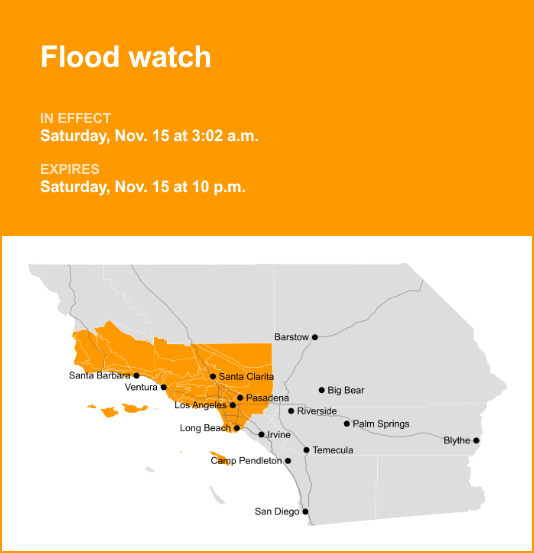
Los Angeles County is under a flood watch which was released by the National Weather Service on Saturday at 3:02 a.m. The watch is in effect until 10 p.m.
The NWS Los Angeles/Oxnard CA said, “Flooding caused by excessive rainfall continues to be possible.”
“Ample roadway flooding with a number of closures are possible, including rockslides and mudslides on canyon roads. Some neighborhoods may experience shallow flooding of buildings. Heavy and dangerous flows are expected in rivers and creeks, with one or two creeks possibly overflowing as well as an increase in swift water rescues. At least shallow or minor debris flows are expected over recent burn scars, with a moderate risk of significant and damaging debris flows primarily for the Palisades, Eaton, and Bridge burn scars,” according to the NWS. “You should monitor later forecasts and be alert for possible Flood Warnings. Those living in areas prone to flooding should be prepared to take action should flooding develop.”
The full list of affected locations includes:
- Catalina/Santa Barbara Islands
- Santa Clarita Valley
- Malibu
- Los Angeles County Beaches
- Palos Verdes Peninsula
- Los Angeles County Inland Coast including Downtown Los Angeles
- Western Santa Monica Mountains Recreational area
- Eastern Santa Monica Mountains Recreational area
- Calabasas/Agoura Hills
- San Fernando Valley
- Santa Susana Mountains
- 5 Freeway corridor near Santa Clarita
- Western San Gabriel Mountains/Highway 14 Corridor
- Eastern San Gabriel Mountains
- Western Antelope Valley Foothills
- Eastern Antelope Valley Foothills
- Antelope Valley
- San Gabriel Valley
- Santa Barbara County Central Coast Beaches
- Santa Barbara County Inland Central Coast
- Santa Ynez Valley
- Santa Barbara County Southwestern Coast
- Santa Barbara County Southeastern Coast
- Santa Ynez Mountains Western Range
- Santa Ynez Mountains Eastern Range
- Santa Barbara County Interior Mountains
- Ventura County Beaches
- Ventura County Inland Coast
- Lake Casitas
- Ojai Valley
- Central Ventura County Valleys
- Southeastern Ventura County Valleys
- Southern Ventura County Mountains
- Northern Ventura County Mountains
- San Miguel/Santa Rosa Islands
- Santa Cruz/Anacapa Islands
Breaking down weather alerts: advisories, watches, and warnings
- Flash flood warning: Take action!
A flash flood warning is issued when a flash flood is either imminent or already occurring. In flood-prone areas, it’s crucial to move immediately to higher ground. A flash flood is a sudden and violent inundation that can develop within minutes to hours, and it can even happen in areas not currently experiencing rainfall.
- Flood warning: Take action!
A flood warning is declared when flooding is on the verge of happening or is already underway.
- Flood advisory: Be aware:
A flood advisory is issued when flooding is not expected to be bad enough to issue a warning. However, it may cause significant inconvenience, and if caution is not exercised, it could lead to situations that may threaten life and/or property.
- Flood watch: Be prepared:
A flood watch is issued when conditions are favorable for flooding. It doesn’t guarantee that flooding will occur, but it signifies that the possibility exists.
Keeping safe during floods: Expert advice from the NWS
Floods can pose a significant threat, especially if you live in a flood-prone area or find yourself camping in a low-lying region. To ensure your safety, the NWS offers essential flood safety guidelines:
Seek higher ground:
If you’re in a flood-prone area, or if you’re camping in a low-lying spot, move to higher ground as a first step.
Adhere to evacuation orders:
If local authorities issue an evacuation order, heed it promptly. Prior to leaving, secure your home by locking it.
Disconnect utilities and appliances:
If time allows, disconnect your utilities and appliances. This reduces the risk of electrical hazards during flooding.
Steer clear of flooded basements and submerged areas:
Avoid basements or rooms submerged in water with electrical outlets or cords. Preventing electrical accidents is crucial.
Swift evacuation for your safety:
If you notice sparks or hear buzzing, crackling, snapping, or popping noises, evacuate immediately. Avoid any water that may be charged with electricity.
Refrain from walking in floodwaters:
Never attempt to walk through floodwaters, even if they appear shallow. Just 6 inches of fast-moving water can forcefully sweep you off your feet.
Seek high ground if trapped:
In the event you become trapped by moving water, make your way to the highest point available and contact emergency services by calling 911.
During periods of heavy rainfall, especially in low-lying and flood-prone areas, the risk of flooding escalates. Remember this crucial advice: never attempt to drive through water on the road, even if it appears shallow. According to the NWS, as little as 12 inches of rapidly flowing water can carry away most vehicles. Stay safe by being prepared and informed.
Navigating heavy rain: Essential safety measures for wet roads
When heavy rain strikes, safety is paramount. Equip yourself with these guidelines from the NWS to navigate wet roads and avoid hazards:
Beware of swollen waterways:
Avoid parking or walking in close proximity to culverts or drainage ditches, as the swiftly moving water during heavy rain can potentially carry you away.
Maintain safe driving distances:
Adhere to the two-second rule for maintaining a safe following distance behind the vehicle in front of you. In heavy rain, allow an additional two seconds of distance to compensate for reduced traction and braking effectiveness.
Reduce speed and drive cautiously:
On wet roads, slowing down is paramount. Gradually ease off the accelerator and avoid abrupt braking to prevent skidding.
Choose your lane wisely:
Stick to the middle lanes on multi-lane roads to minimize the risk of hydroplaning, as water tends to accumulate in outer lanes.
Prioritize visibility:
Turn on your headlights and be careful of other vehicles to the rear and in blind spot areas as they are especially difficult to see through rain-spattered windows.
Watch out for slippery roads:
Be extra careful during the first half hour after rain begins. Grime and oil on the road surface mix with water to make the road slippery.
Keep a safe distance from large vehicles:
Large trucks and buses can reduce your visibility with tire spray. Avoid tailgating and pass with caution.
Mind your windshield wipers:
- Overloaded wiper blades can hinder visibility. If rain severely limits your sight, pull over and wait for conditions to improve. Seek refuge at rest areas or protected spots.
- When stopping by the roadside is your only option, position your vehicle as far off the road as possible, ideally beyond guardrails. Keep your headlights on and activate emergency flashers to alert other drivers of your position.
In the face of heavy rain, these precautions can make a significant difference in ensuring your safety on the road. Remember to stay informed about weather conditions and heed guidance from local authorities for a secure journey.