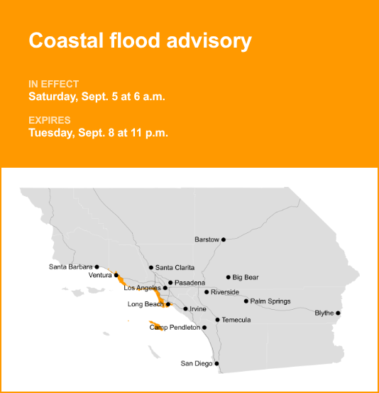
Catalina/Santa Barbara Islands, Malibu, Los Angeles County Beaches and Ventura County Beaches are the focus of a coastal flood advisory released at 12:11 p.m. on Thursday by the National Weather Service. The advisory is valid from Saturday 6 a.m. until Tuesday Sept. 8, at 11 p.m.
“Moderate coastal flooding expected,” according to the NWS Los Angeles/Oxnard CA. “High tides will occur around 5pm on Saturday, 6pm on Sunday, 7pm on Monday, and 8pm on Tuesday.”
“There is an increased risk for ocean drowning. Rip currents can pull swimmers and surfers out to sea. Large breaking waves can cause injury, wash people off beaches and rocks, and capsize small boats near shore. Enhanced beach erosion will occur. Flooding of sea water is likely, around the time of high tide, over vulnerable low-lying coastal areas such as parking lots, beaches, and walkways. Significant damage to roads or structures is NOT expected,” the NWS said. “Remain out of the water due to dangerous surf conditions, or stay near occupied lifeguard towers. Rock jetties can be deadly in such conditions, stay off the rocks. Follow advice from local officials. Do NOT drive around barricades or through water of unknown depth.”
Breaking down weather alerts: advisories, watches, and warnings
Flash flood warning: Take action.
A flash flood warning is issued when a flash flood is imminent or occurring. If you are in a flood-prone area, move immediately to high ground. A flash flood is a sudden violent flood that can take from minutes to hours to develop. It is even possible to experience a flash flood in areas not immediately receiving rain.
Flood warning: Take action.
A flood warning is issued when flooding is imminent or occurring.
Flood advisory: Be aware.
A flood advisory is issued when flooding is not expected to be bad enough to issue a warning. However, it may cause significant inconvenience, and if caution is not exercised, it could lead to situations that may threaten life and/or property.
Flood watch: Be prepared.
A flood watch is issued when conditions are favorable for flooding. It doesn’t guarantee that flooding will occur, but it signifies that the possibility exists.
Staying safe during a flood: Recommendations from the NWS
Floods can pose a significant threat, especially if you live in a flood-prone area or find yourself camping in a low-lying region. To ensure your safety, the NWS offers essential flood safety guidelines:
Move to higher ground:
If you reside in a flood-prone region or are camping in low-lying terrain, the first step to safety is relocating to higher ground.
Follow evacuation orders:
When local authorities issue an evacuation order, promptly comply. Before leaving, secure your home by locking it.
Disconnect utilities and appliances:
If time permits, disconnect your utilities and appliances. This precaution minimizes electrical hazards during flooding.
Avoid basements and submerged areas:
Avoid basements or rooms submerged in water with electrical outlets or cords. Preventing electrical accidents is crucial.
Evacuate promptly for safety:
If you notice sparks or hear buzzing, crackling, snapping, or popping sounds, evacuate without delay. Do not enter water that may carry an electrical charge.
Stay away from floodwaters:
Never attempt to walk through floodwaters. Even just 6 inches of swiftly moving water can forcefully knock you off your feet.
Seek high ground if trapped:
Should you become trapped by moving water, reach the highest point possible and dial 911 to contact emergency services.
When heavy rain occurs, there is a risk of flooding, particularly in low-lying and flood-prone regions. It is important to never attempt to drive through water on the road, regardless of how deep it appears. According to the NWS, as little as 12 inches of rushing water can sweep away most vehicles. Prioritize your safety by staying informed and prepared.
For more local weather alerts, visit our Weather Advisory page