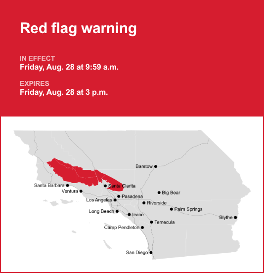
Santa Susana/San Gabriel Mountains is the focus of a red flag warning issued at 9:59 a.m. on Friday by the National Weather Service. The warning is in effect until 3 p.m.
Expect winds to be local north winds 15 to 25 mph with gusts up to 35 mph across the interior mountains today, along with strong/erratic wind gusts near any passing thunderstorms or showers and relative humidity minimum humidities 12 to 25%. Poor recoveries overnight hours in the mountains and foothills with humidities in the 20 to 30% range.
“A hot and unstable air mass combined with locally gusty/erratic winds and low humidities will bring continue to bring a risk of large plume dominated fires with rapid spread and extreme fire behavior. Additionally, tropical moisture streaming across our area will bring a 10-25% chance of thunderstorms to the region, with a moderate risk for fire starts across San Luis Obispo County due to dry lightning potential,” says the NWS Los Angeles/Oxnard CA. “There is a continued risk of large plume dominated fires with rapid fire spread and extreme fire behavior. There is a history of large plume dominated fires this time of year with similar weather and fuel conditions, including the Bridge, Bobcat, and Station fires.”
The full list of affected locations includes:
- 5 Freeway corridor near Santa Clarita
- Western San Gabriel Mountains/Highway 14 Corridor
- Cuyama Valley
- Santa Barbara County Interior Mountains
- Southern Ventura County Mountains
- Northern Ventura County Mountains
Emergency alerts in Southern California
For “considerable or catastrophic” hazards, emergency alerts will be sent to all enabled mobile phones in the area. To monitor lesser risk, residents are advised to sign up for county alert systems and to monitor agencies’ social media. How to sign up for alerts in your area:
What does a red flag warning indicate?
A red flag warning signifies that either extreme fire weather conditions are currently in effect or will be shortly, as stated by the NWS. Warm temperatures, very low humidities, and stronger winds are expected to combine to produce an increased risk of fire to spread rapidly.
What are the recommended measures to take during a red flag warning?
A red flag warning demands vigilance and immediate readiness to respond to potential fires. The NWS provides these vital guidelines to minimize fire hazards and ensure your safety:
1. Bolster burn barrel safety:
If burning is authorized in your vicinity, ensure that all burn barrels feature a weighted metal cover with holes no larger than 3/4 of an inch.
2. Mindful disposal of smoking materials:
Steer clear of haphazardly discarding lit cigarette butts and avoid flinging cigarettes or matches from moving vehicles. These innocuous-seeming actions can kindle dry vegetation, potentially spawning a wildfire.
3. Prudent fire extinguishing practices:
To thwart accidental fires, diligently extinguish all outdoor fires. Suffocate them with an ample deluge of water and stir to ensure complete cooling. Submerge charcoal in water until it’s entirely devoid of heat. Never leave live charcoal unattended.
4. Never desert a blaze:
Avoid abandoning any fire without supervision. Even minor sparks or drifting embers can incite nearby foliage or grass, setting off a rapidly spreading fire.
Understanding the gravity of a red flag warning and adhering to these precautions is pivotal in mitigating the risk of wildfires during these perilous conditions. Prioritize safety, stay well-informed, and act responsibly to safeguard lives and property.
For more local weather alerts, visit our Weather Advisory page