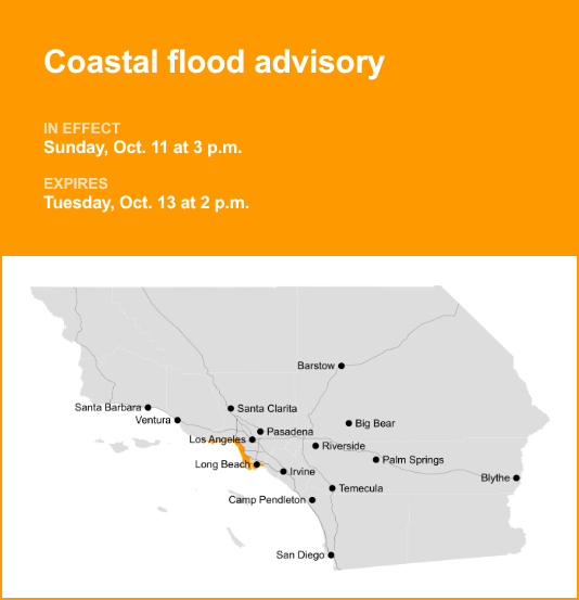
Malibu and Los Angeles County Beaches were placed under a coastal flood advisory by the National Weather Service on Saturday at 1:51 p.m. The advisory is valid from Sunday 3 p.m. until Tuesday Oct. 13, at 2 p.m.
“DAMAGING sea-water coastal flooding is likely through Sunday, especially near the Sunday morning high tide where anticipated tide levels are expected to be around 8 feet. The most likely areas for DAMAGING coastal flooding on Sunday morning will be vulnerable south-facing beaches due to the expected combination of very high level tide levels around 8 feet (including additive effect of low barometric pressure and onshore winds gusting to 15 to 25 mph), high surf of 5 to 8 feet, and light to moderate rainfall. For all other beaches, minor to moderate coastal flooding is expected near times of high tide. From Sunday night through Tuesday, there will be the continued threat of at least minor to moderate coastal flooding and elevated surf across Los Angeles county beaches, especially south facing shores. Dangerous rip currents are likely,” according to the NWS Los Angeles/Oxnard CA. “High tides of around 8 feet are expected on Sunday morning (nearly 2 feet above astronomical high tide of 6.1 feet), returning to around 7.5 feet for Monday and Tuesday mornings. The projected high tides of around 8 feet for Sunday morning would approach or exceed recent record tide levels for LA county. Large secondary high tides are also expected each evening.”
“For vulnerable south-facing beaches (such as Alamitos Peninsula and Naples in Long Beach as well as Malibu), SIGNIFICANT sea- water flooding will likely DAMAGE coastal structures and beach roadways around the time of high tide, especially the Sunday morning high tide. In addition, significant ponding of water on low-lying beach roadways could make driving difficult. THERE IS GROWING CONFIDENCE THAT THE EXPECTED COASTAL FLOODING IMPACTS ON SUNDAY MORNING FOR VULNERABLE SOUTH FACING BEACHES OF LA COUNTY COULD BE THE MOST SIGNIFICANT WE HAVE SEEN SO FAR THIS SEASON, INCLUDING THOSE SEEN WITH MARIE. For all other beaches and harbors, shallow with minor to moderate sea- water flooding will likely impact beaches and walkways, especially with the Sunday morning high tide which could cause local damage to most vulnerable locations such as Venice. For all beach areas, significant erosion is expected. There is an increased risk for ocean drowning. Dangerous and life- threatening rip currents can pull swimmers and surfers out to sea. Large breaking waves can cause injury, wash people off beaches and rocks, and capsize small boats near shore,” the NWS said. “Follow directions of emergency officials. Stay off of beaches and coastal walkways, roads, and structures. Do NOT drive around barricades or through water of unknown depth. Remain out of the water due to dangerous surf conditions, or stay near occupied lifeguard towers. Rock jetties can be deadly in such conditions, stay off the rocks.”
Breaking down weather alerts: advisories, watches, and warnings
Flash flood warning: Take action.
A flash flood warning is issued when a flash flood is either imminent or already occurring. In flood-prone areas, it’s crucial to move immediately to higher ground. A flash flood is a sudden and violent inundation that can develop within minutes to hours, and it can even happen in areas not currently experiencing rainfall.
Flood warning: Take action.
A flood warning is declared when flooding is on the verge of happening or is already underway.
Flood advisory: Be aware.
A flood advisory is issued when flooding is not expected to be bad enough to issue a warning. However, it may cause significant inconvenience, and if caution is not exercised, it could lead to situations that may threaten life and/or property.
Flood watch: Be prepared.
A flood watch is issued when conditions are favorable for flooding. It does not mean flooding will occur, but it is possible.
Weathering the storm: Flood safety guidelines from the NWS
Floods can pose a significant threat, especially if you live in a flood-prone area or find yourself camping in a low-lying region. To ensure your safety, the NWS offers essential flood safety guidelines:
Move to higher ground:
If you reside in a flood-prone region or are camping in low-lying terrain, the first step to safety is relocating to higher ground.
Follow evacuation orders:
When local authorities issue an evacuation order, promptly comply. Before leaving, secure your home by locking it.
Disconnect utilities and appliances:
If time allows, disconnect your utilities and appliances. This reduces the risk of electrical hazards during flooding.
Steer clear of flooded basements and submerged areas:
Steer clear of basements or rooms where water has submerged electrical outlets or cords. This helps prevent electrical accidents.
Swift evacuation for your safety:
If you notice sparks or hear buzzing, crackling, snapping, or popping sounds, evacuate without delay. Do not enter water that may carry an electrical charge.
Refrain from walking in floodwaters:
Never attempt to walk through floodwaters, even if they appear shallow. Just 6 inches of fast-moving water can forcefully sweep you off your feet.
Seek high ground if trapped:
Should you become trapped by moving water, reach the highest point possible and dial 911 to contact emergency services.
When heavy rain occurs, there is a risk of flooding, particularly in low-lying and flood-prone regions. It is important to never attempt to drive through water on the road, regardless of how deep it appears. According to the NWS, as little as 12 inches of rushing water can sweep away most vehicles. Prioritize your safety by staying informed and prepared.
For more local weather alerts, visit our Weather Advisory page